Images


Details
https://www.supercheapauto.com.au/p/hema-hema-k%E2%80%99gari-fraser-island-map-%E2%80%93-10th-edition/667790.htmlPromotions
Additional Information
Product Info
Product Info
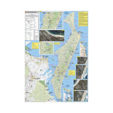
The Hema Map Fraser Island Map 10th Edition is the ultimate navigation tool for discovering the natural beauty of one of Australia’s most iconic destinations. Proudly produced and printed in Australia, it features detailed 4WD tracks that have been fully checked by Hema’s expert Map Patrol team, giving you confidence as you explore Fraser Island’s stunning beaches, forests and inland lakes. Designed for adventure, it provides all the information you need to plan and enjoy your journey on this world-famous sand island.
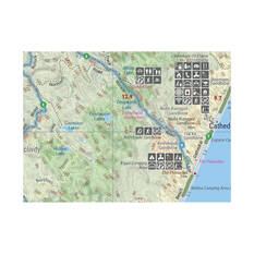
With GPS-surveyed roads and tracks, this map ensures exceptional accuracy, helping you stay on course whether you’re heading to popular spots or venturing off the beaten path. It includes clear coverage of camping areas, making it easy to find the perfect spot to set up for the night, while satellite images of key locations give you an extra level of detail for better orientation. Inset maps of the island’s national parks highlight walking trails, attractions and protected areas, so you can make the most of your visit.
Featuring points of interest across Fraser Island, the Hema Map Fraser Island Map 10th Edition is a reliable, easy-to-use companion for four-wheel drivers, campers and nature lovers alike. Its robust design and expert data make it an essential resource for experiencing everything this remarkable destination has to offer.
Features
- Produced and printed in Australia
- Detailed 4WD tracks fully checked by Hema's Map Patrol
- Covers camping areas
- GPS surveyed roads and tracks
- Satellite images of key locations
- Detailed national park inset maps
- Points of interest